A JOLLY HOUR ON THE TROLLEY
By Grace D. Wheeler
(From Historical Footnotes, February 2006)
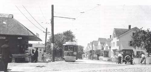
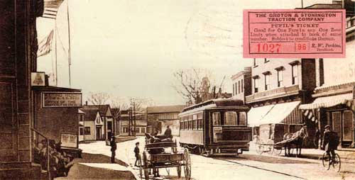
A century ago, it was possible to ride across the towns of Stonington and Groton, between the Pawcatuck River bridge and the Thames River, in about an hour and a half. The conveyance was the interurban trolley service operated by the Groton and Stonington Street Railway. This journey, over coves and estuaries of the Atlantic, up hills, past factories and historic sites, and through the woods, cost a nickel.
The Groton and Stonington line, having won a charter from the legislature in 1903, opened service to the public on December 19, 1904. As a promotion device, the line commissioned Grace Denison Wheeler, author of a popular book of 1903, Homes of Our Ancestors in Stonington, to describe the historical wonders of the route. Miss Wheeler wrote a narrative starting at the eastern terminus, with a detailed picture of the historic layers of activity there, from grist mills to thread mills. She noted frequently the speed of the trip, cautioning others to take the journey more than once to be able to pick out the sights. [more...]
Here on the bridge in Westerly we take the car, and remember when we do that Rhode Island is but a step to the eastward, though in 1629 Connecticut extended her limit four miles east to Weekapaug; and when the Stonington & Providence railroad [later the New York, New Haven & Hartford] was about to be constructed in 1832, a portion of Rhode Island soil was wheeled into Connecticut and vice versa, while Hon. Nathan F. Dixon offered the sentiment, "Connecticut and Rhode Island, may they improve by mixing!"
The old ford or wading place called Kitchamaug was on this Pawcatuck River, a few rods below here, but was abandoned when all travel from Misquamicut (Westerly) to Pequot (Stonington) passed over a bridge built here in 1712 by subscription, raised by Capt. Joseph Saxton of Stonington and John Babcock of Westerly, and for many years the present village of Westerly was called The Bridge.
In 1661 we see at the left the first Ordinary or Public House in Stonington, kept by Thomas Shaw, while just above Kitchamaug, in 1666, Elder John Crandall operated a grist mill, the second in town. Near here was also a sawmill owned by Jonathan Richardson and run by Elias Brown, who lived in one half of the long house at the left, while on the other side Dr. William Robinson kept a boarding house. Look out of your car window at the right and see the Martha Noyes house, called "The Inn" a hundred years ago, when kept by Samuel Brand; now it is nearly concealed by small stores. See next to this theThomas Noyes mansion, which was in early days built in grand style.
As you leave the bridge, you think of the Old Post Road, laid out in 1669, from Head of Mystic [Old Mystic] to Kitchamaug, and how Capt. George Denison was empowered to make a directory and set it up on a tree or post near the wading place at Pawcatuck River, so that traveling strangers might find the country highway through the town to the New London highway at Mystic River. Over this road in 1675 went the early settlers to the Great Swamp fight, and here also Capt. John Mason led his forces of white men and Indians to the Pequot war. At the right, in 1853, stood the brick Pawcatuck Hotel, known as the "Red Jug." As you turn, near the railroad viaduct, or "dry bridge," you see at the right a grand old elm tree, throwing its protecting shade over the old home of George Sheffield. A little west of here, running parallel with Mechanic street, down which you are going, was once the noted trotting track, where crowds would assemble to witness the horse races, one of the amusements of the times.
Now we pass the printing press works of the Cottrell Brothers, and get a fine view of the river, flowing swiftly out to Little Narragansett Bay. Here we come to a sharp turn at the right, where stands the extensive plant of the Clark thread mill; now up the hill, on the summit of which stands the historichomestead of Paul Babcock.
This house was built by Dr. Joshua Babcock, at one time Chief Justice of Rhode Island's Superior Court. He gave it to his son (the father of Paul), Col. Harry Babcock, who was a brave officer in many battles. Once, being in England, he was allowed an appointment with the Queen, whom he saluted with a kiss upon her cheek instead of her hand, which she graciously extended to him, and we do not hear that he was reprimanded for his audacity. From here we look off across the river and see the oldDenison farm; and the grave of George and Mercy Gorham Denison in the meadow, nearly opposite the Pawcatuck Rock, where Thomas Stanton, the Indian interpreter, built his trading house in 1656, the only commercial place in this whole section; and here, also, his granddaughter Dorothy lived, who had such a romantic career, marrying four times and living to be 105 years old.
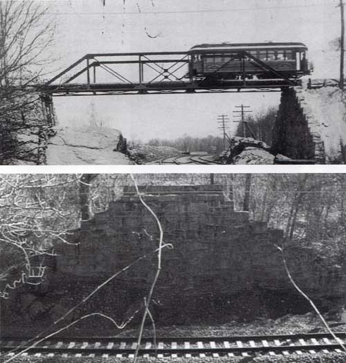
Now moving on rapidly past Clarkville, with its neat houses and gardens, over the high bridge [over the railroad tracks], among tall trees, we catch a glimpse of an old gambrelled roof house, built in 1740, and occupied later by Joshua Robinson. Soon we come to the switch, on land of Dr. George D. Stanton, who owns the old Nehemiah Palmer house, which you see on the left, built in 1700, standing brown and square roofed on the road known as "the Indian Trail" [Greenhaven Road] to Pawcatuck Rock, which you now cross and get a view of Wequetoquock Cove and the old graveyard at the left, where stands amid many old stones the new monument erected by descendants of four of the early settlers of the town, viz: William Chesebrough, Walter Palmer, Thomas Stanton and Thomas Miner. Off at the right on the hill once stood the first grist mill in town, built in 1662, and the old mill house nearby, which is mentioned in the agreement signed by the early settlers in 1661. Near here we see acomparatively new chapel for religious worship, reminding us that Rev. James Noyes, first minister in Stonington, lies buried in the old yard opposite. He was one of the founders of Yale College, a distinguished preacher, and during his pastorate of fifty five years at the First Church (Road) he baptized 1176 persons.
Looking close to your right, you see the old home, in 1698, of the Scotch Irishman, Fergus McDowell, its garden running down to the head of the cove, where
"You can see the gap in the old stone wall,
And the stepping stones in the shallow brook."
These were used for crossing the stream, which was sometimes a rushing torrent. As you cross the water to the highway, on the west bank, overlooking the cove, we pass the spot where the first white man, William Chesebrough, gunsmith and blacksmith, built for his home the first house in Stonington, in 1640. Nearly opposite, on the west side of the cove, lived Walter Palmer, his next neighbor, to whom he could speak from his door. Now we pass at the right the house which Gov. Thurston of Rhode Island built in 1787, where a tavern used to stand, a school was kept, and trainings were held. See at the left a low house, the west end facing the road and nearly covered with trailing rose vines [now part of Coveside Marina]. Here King David Chesebrough once lived. During the Revolution he lived at Newport and had all his property confiscated by the English, after which he returned and lived here, keeping a store. On this farm now stands the new Casino, flags flying, inviting the public to enjoy its many pastimes and to find refreshment for both mind and body [casino burned June 14, 1940; site is opposite Buzzi Memorial Works]. All along the way to Stonington we get charming views of the ocean, Watch Hill, and Fort Mansfield [at the end of Napatree Point], with their large hotels and soldiers' quarters, from which booms the sunset gun every evening.
From the hill near Elm street, in Stonington Borough, we see at the left the Velvet mill, a new industry here, and a nearer approach to Stonington reminds us of the British attack in 1814, when the citizens so nobly and successfully defended their homes. The cannon and bombs are still to be seen which played such an important part in that battle.
Now make an abrupt turn at Elm street, run along a sort distance, and when the conductor calls "Stonington!" look out and see the station [now a home next to the footbridge over the rail tracks] standing on the site of the old salt works, which, sixty years ago, made an industry here. The salt water from the harbor flowed through pipes into a tank, which was then pumped by windmill power into shallow vats, to be evaporated by the heat of the sun. The vats were provided with movable covers, which were placed over them in rainy weather. Just south of here was a cross road, so that teams could come from Main or Front street to the road running to the cove (as there was no street into the village on the west side), that being then the "Robinson Pasture." As you make the curve, you will see directly west Nat's Point Shipyard [site of Wadawanuck Club]. Now on past the home of the late Captains Palmer of whaling [sealing] days fame, of whom Capt. Nat was the discoverer of the most northerly point of Antarctica, called in his honor "Palmer Land."
Here, turning abruptly, you catch a breeze from the water, and see before you Lambert's cove and bridge, which latter was a bone of contention for many years. Traveling in the early days was by horseback and ox teams. The roads were not graded nor the brooks bridged, and this was no exception until in 1801 a petition to the General Court asked for a layout of this road to Old Mystic. Then a lottery scheme was proposed to build a bridge, and later a ferry charter to cross Lambert's cove to Quanaduct. The people at the north objected so strongly to this road that it resulted in dividing the town in 1807 (which event North Stonington will celebrate this autumn). This road was finally opened by the sheriff in 1815. The first bridge built was barely wide enough to allow a single team to pass, but later it was widened and a middle pier constructed.
As yew cross the present bridge you will see at the left "Wamphassett," or "Wampossett," as it was called when, in 1653, it was owned by Hugh Calkins, the name signifying a white land or land frequented by white birds. In 1776 Major Israel Hewitt of "Bear's Den" fame gave in his will to his two granddaughters, Amy Stanton and Anne Ledyard (wife of Col. William Ledyard), a part of this same land, lying near to Capt. Israel Wordin's house. Quanaduct lies north of this bridge, and at the right, almost hidden among tall trees, is the Day Place or Walnut Grove, in earlier times known as the Gershom Lambert estate. Making the curve, you pass the Grandison Chesebrough homestead (now a barn), where the late Rev. Amos Chesebrough of New Hartford lived in his youth. Now on past the Catholic cemetery and the little school house [formerly at the entrance of Wamphassett Point, obliterated in the hurricanes of 1938 and 1944].
"Those words contain a secret spring
That memory's floodgates swing,
And recollections to us bring
Of happy days of yore."
To be a schoolmaster in the olden time was to be an oracle of wisdom for young and old. Read the agreement between John Stoyell of Voluntown and John Stanton and Nathaniel Gallup, gentlemen undertakers of a school in the southwesterly part of Stonington, which shows how instruction in reading, writing, and arithmetic for six months was compensated by finding said Stoyell in meat, drink, washing, and lodging, keeping his horse, and sixty pounds in old tenor money at the end of the term of six months school.
At Harborside station a road from Wamphassett crosses to the right, leading past the old Richardson estate (now occupied summers by Judge Gilbert Collins's family). This place was noted as the hiding place of Capt. Kidd's "ninety pieces of eight" in 1699.
Now up the hill, past Montauk avenue, which stretches away to the north by beautiful homes, with a view of Lantern hill in the dim distance, we make a bend in the road and get a glorious view of the Sound, "the Point," Watch Hill, and many islands, with old ocean showing its best as a background, gray and misty. Here at the right is Darling Hill, where stood for years "the Farmers' Palace," but where now are several summer homes. Let your eye rest for a moment in the near door yard.
"On the sweet old fashioned posies,
Quaint inform and bright in hue,
Marigolds with coats of yellow
Morning glories, pink and blue."
As we go swiftly around the curve, Cedar Point [Lord's Point] is in view at the left, with its summer colony, and in the distance the building of the Wilcox industry. Crossing the bridge, we come to Latham's "neck," and the Thomas Miner homestead, facing the water of Quiambaug cove. Here, in 1655, dwelt one of the pioneers of Stonington, and now the ninth generation, with the same name, occupies the house. Could you stop and read the epitaphs on the old stones in the little graveyard at the left, you would be both amused and instructed.
Up the hill and through Wilcoxville, past the site of the old Green homestead, which is nearly opposite one of modern architecture, you go on over the marshland, which in early days was a great incentive to the pioneers to settle here that they might have the salt marsh grass for their cattle. Now up the hill we see where, in 1700, stood the old Williams house, in "Que-an-te-qua-hood's field," just north of the present home of Dea. B.F. Williams, vice president of this road. Opposite the house is the path to the Old Riding Way, which was the fording place between Mason's Island and the mainland; then past Williams Cove, where in 1814, the English soldiers, attempting to destroy the village of Mystic, entered by mistake east of Mason's Island and ran their vessels, in the thick darkness, into this cove. The soldiers scrambled overboard to get their barge into better water, but only sank their red coats and royal gilt button their their waists in mud.
As you cross the bridge, in the field to the right, unprotected by anything except tall weeds and grasses, are the graves of the old Masons, whose home was on Chipachaug or Mason Island, which you will see across the water to the left. This island was granted to Major John Mason in 1651 by the General Court of Connecticut for his gallant services in the Pequot War, of which he was the leader in 1637. The youngest son of Major Mason occupied this domain for many years, and even now there are descendants of the same name living there. Bringing your eye back to nearer objects, you see close beside you, at the left, the old Denison yard, recently renovated, where Lady Ann Borrowdale, wife of Capt. George Denison, was first buried though later carried to Elm Grove cemetery, while her husband lies buried at Hartford, where he was on business at the time of his death.
An abrupt turn to the left takes you into the pleasant village of Mystic, and soon we see the home officeof the Southern New England Telephone Company, and then the tall spire of the Congregational church comes into view, which has stood there for more than fifty years, opposite which is the monument dedicated, in 1883, to the soldiers who fell in the War of the Rebellion.
"Then silent, along shall this momument stand,
Recalling the heroes that rescued our land:
A new generation shall walk round its base,
Inquiringly scanning its patriot face,
And oft little children shall pause in their plays
To ask for the deed of their forefathers' days."
When the bridge is reached, we cross Sicanemons, the Indian name for Mystic river, which, during the reign of Gov. John Winthrop, from 1657 to 1675, was pronounced the western border of Connecticut, as it is now the western boundary of Stonington. This town was called Southertown at first, and until 1865, when, at the General Court, it was named "Mystick" in memory of that victory God was pleased to give this people over the Pequot Indians: but the very next year the General Court said, "The town of Mystick is by this court named Stonington."
The river used to be ferried across, and the story is told of an old lady who took her knitting and crossed in the boat to find, when she reached the opposite shore, that her ball of blue yarn was on one side of the river and she and her stocking on the other.
* * *
When Miss Wheeler reaches the end of her journey, at a church in Groton, she concludes:
And then come down the hill again and take the trolley to Westerly, thinking why are we blessed with so much beauty of scenery and historical interest along this route, unless it is that we may love and praise more devoutly the Great Architect of all.